NCERT Solutions for Class 7 Social Science Chapter 8 How the Land Becomes Sacred – step-by-step answers to every exercise and in-text question of the chapter, as per the latest NCERT syllabus for 2027. Read them online or download the free question-answer PDF.
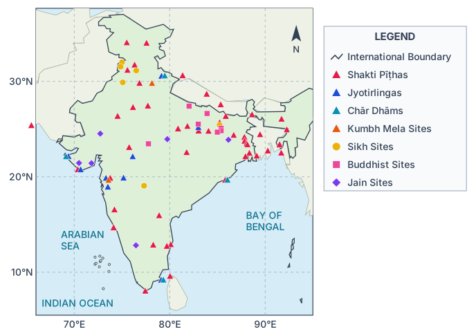
Answers to Chapter 8, How the Land Becomes Sacred, of the NCERT Class 7 Social Science textbook Exploring Society: India and Beyond (Part 1, Theme C Our Cultural Heritage and Knowledge Traditions): The Big Questions, the five LET’S EXPLORE boxes, the DON’T MISS OUT question on the Kumbh Mela, both THINK ABOUT IT boxes, the in-text questions on pages 179 and 180, Before we move on … and all eight Questions and activities. The map of traditional tīrthas (Fig. 8.6) is redrawn with India’s official boundary.
NCERT Solutions for Class 7 Social Science Chapter 8 How the Land Becomes Sacred PDF
All the answers are on this page below. The PDF also explains every answer – why it is right and how to check it – so download it for revision.
| Chapter | Download | |
|---|---|---|
| Solutions PDF | How the Land Becomes Sacred | View PDF |
NCERT Solutions for Class 7 Social Science Chapter 8 How the Land Becomes Sacred – Questions and Answers
All 27 questions of the chapter (textbook pages 167 – 184) are answered below, in the order of the book – in-text questions, activities and the end-of-chapter exercises. Each answer is written the way you would write it in the exam.
The Big Questions — Page 167Chapter opening — Theme C, Our Cultural Heritage and Knowledge Traditions
Sacredness is finding something of deep religious or spiritual significance — something worthy of respect and reverence, holy or divine. This ‘something’ can be a special place or shrine, a special journey (a pilgrimage), the route that journey takes, or even the very land covered. So sacredness is linked not only with religion and spirituality but also with geography and traditions.
The land becomes sacred when sacred places cover it and are linked into networks. In many Indian traditions Nature itself — mountains, rivers, forests, trees — is seen as divine. Networks such as the chār dhām, the 12 jyotirlingas and the 51 Shakti pīṭhas crisscross India, and pilgrims have walked them for at least 3,000 years. Stories, like that of the Shakti pīṭhas, make the whole land the body of the divine mother.
Sacred sites and pilgrimage networks touch almost every part of people’s lives. Spiritually, a pilgrimage is an inner journey. Economically, pilgrims give work to traders, shopkeepers, boatmen and lodges, and pilgrim and trade routes overlap. Socially and culturally, people travel in groups, meet other languages, customs and foods, and share ideas. Ecologically, protecting a sacred river, hill or grove protects Nature.
Sacred geography was a major factor in the cultural integration of the Indian Subcontinent. Sacred sites were spread over the whole land (the four dhāms even sit at its four corners), so pilgrims crossed it north–south and east–west. On the way they met different languages, customs, clothing and foods, noticed what was common, and exchanged goods, stories and ideas with traders and teachers. This spread shared values and ‘the feeling of one country and one culture’.
LET’S EXPLORE — Page 168Fig. 8.2 and the chapter-opening pictures of Fig. 8.1
What the pictures show — Fig. 8.1 (chapter opening, page 167) and Fig. 8.2 (page 168):
- Fig. 8.1, six photographs: (1) a group of stone temples with slate roofs standing in a deodar forest; (2) rows of lit diyas floating on a river at night, with the lights of the bank reflected in the water; (3) a white Buddhist stūpa with a golden spire on a bare, rocky mountain; (4) a small pillared shrine standing in the middle of a temple tank; (5) tall upright standing stones in an open grassy field; (6) a close-up of tree roots covered with threads, bead strings, lemons, flowers and other offerings.
- Fig. 8.2, five photographs: (1) a crowded dargah, with men and women seated on the floor under a red canopy; (2) the interior of a synagogue, with a brass-railed platform standing on an orange cloth; (3) the gateway of a Parsi fire temple, with an inscription over the door and a carved winged guardian figure beside it; (4) a large red sandstone mosque with two minarets and white marble domes; (5) another synagogue interior with chandeliers, brass pillars and a red curtain over the ark.
Yes. The tree root tied with threads and offerings (Fig. 8.1) is like the old peepul at our street corner, which nobody cuts. The river with floating lamps is like the ghat we visit on Kartik Purnima. Near my home there are also a small hill temple, a dargah, a church and a gurdwara — sacred places visited by people of many communities.
LET’S EXPLORE — Page 171Dharampal’s account of pilgrims travelling from Rameswaram to Haridwar
Observations: the pilgrims were ordinary villagers — about twelve men and women from two villages north of Lucknow — on a three-month pilgrimage. They carried their own food (atta, ghee, sugar) and earthen pots, travelled by train as one group, and were determined to finish their yātrā.
Route: Rameswaram → Madurai → Chennai → Nagpur → Bhopal → Jhansi → Gwalior → Delhi (change trains) → Haridwar.
Why not stop at Delhi: Delhi was not a tīrtha on their list, only a railway junction; Haridwar was. After three months away they had no time or money to spare and wanted to finish the pilgrimage and get home.
Languages: Tamil, then Telugu and Kannada, Marathi in parts of the Deccan, and the local speech of central India and the Ganga plain near Varanasi; Sanskrit at temples and centres of learning.
Communication: through Sanskrit (among priests and scholars), gestures and a few common words, and guides, traders and fellow pilgrims who knew several languages.
Stay: in dharamshalas, temples, monasteries and rest houses on the routes, or camped by rivers and in groves.
Food: food they carried and cooked themselves (rice, flour, dal, ghee), local food of each region, and free meals or prasāda at temples.
LET’S EXPLORE — Page 173Becoming Aware of Sacred Geography — the locations of the chār dhām
The four dhāms are Badrinath (north, Uttarakhand), Puri (east, Odisha), Rameswaram (south, Tamil Nadu) and Dwarka (west, Gujarat) — at the four corners of India. To visit all four, people had to cross the whole country north–south and east–west. On the way they met many languages, foods and customs, but also the same deities and beliefs. So they came to feel that the whole land was one sacred country with a shared culture.
LET’S EXPLORE — Page 174Fig. 8.6, a map showing a few networks of traditional tīrthas

Yes. Reading each symbol against the political map, we can identify, for example:
- Chār dhām: Badrinath, Puri, Rameswaram, Dwarka
- Kumbh Mela: Haridwar, Nashik (also Prayagraj and Ujjain)
- Jyotirlingas: Kedarnath, Varanasi, Somnath, Omkareshwar, Trimbakeshwar, Bhimashankar
- Shakti pīṭhas: Kamakhya (Guwahati), Kalighat (Kolkata), Jwalamukhi, Kanyakumari
- Sikh sites: Amritsar, Anandpur Sahib, Patna Sahib, Nanded
- Buddhist sites: Bodh Gaya, Sarnath, Kushinagar, Sanchi
- Jain sites: Mount Abu, Girnar, Palitana (Śhatruñjaya), Shikharji, Shravanabelagola
DON’T MISS OUT — Page 176Prayagraj, the Kumbh Mela and the confluence of three rivers
Proportion = 66 crore ÷ 145 crore ≈ 0.45 = about 45%
So the 2025 Kumbh Mela figure was about 45% of India’s population — a little less than half.
THINK ABOUT IT — Page 177Figs. 8.7 and 8.8 — the Kumbh Mela and the ghats — and the economic life around a sacred place
What the two pictures above show:
- Fig. 8.7 (page 176) — the Kumbh Mela at dusk: a broad river with an immense crowd packed along the bank, hundreds of people standing in the shallow water, and behind them an unbroken line of lit stalls, tents and lamps running far into the distance under a pink evening sky.
- Fig. 8.8 (page 177) — the ghats of a river town: tall multi-storeyed riverfront buildings in ochre, white, yellow and red rising above a long flight of stone steps; boats moored at the water’s edge, and people, umbrellas and washing spread over the steps.
Sacred places support many livelihoods — transport, places to stay, food and offerings, crafts and shops, services, and fairs and trade. Pilgrims create demand, and demand creates work. Mind map:
In-text Questions — Page 179Fig. 8.12, a seal from Mohenjo-daro — and the THINK ABOUT IT box on the peepul tree
Yes — they are peepul leaves: heart-shaped leaves with long pointed tips, spreading over two horned animal heads. The seal shows that the peepul tree has been important in India’s culture for thousands of years.
In-text Questions — Page 180The table of names for sacred groves in regional languages of India
Yes. Some more names for sacred groves:
| Language / State | Name for a sacred grove |
|---|---|
| Kerala | sarpa kāvu (serpent grove) |
| Manipur (Meitei) | umang lai |
| Odisha | jāhera |
| West Bengal | garāmthān |
| Uttarakhand | deo bhūmi |
LET’S EXPLORE — Page 181From pilgrimage to trade — tracing the trade-route map (Fig. 5.5) over the map of tīrthas
We observe that the trade routes and the tīrtha networks largely overlap. Many cities on the trade routes are also tīrthas or lie close to them — Kāśhī (Varanasi), Ujjayinī (Ujjain), Mathurā, Dvāraka (Dwarka), Kānchīpura (Kanchipuram), Madurai (near Rameswaram). So pilgrims and traders used the same roads and helped each other, and goods, ideas and culture spread across the Subcontinent.
THINK ABOUT IT — Page 182Restoring and conserving the sacred — Fig. 8.18, polluted rivers and sacred animals
What the three pictures show — Fig. 8.18 (page 182):
- A wide river whose surface is covered with thick white toxic foam; on the far bank stand a row of high-rise city buildings and an electricity pylon.
- A brown cow standing on a bank heaped with plastic bags, wrappers and household rubbish, nosing through the waste for food.
- A fast-flowing river below a forested hill, its grassy bank strewn with plastic bottles, bags, packaging and driftwood washed up at the water’s edge.
Why polluted: untreated sewage and factory waste flow into these rivers, plastic and rubbish (even ritual offerings) are dumped in them, and too much water is taken out. People still worship the rivers but do not take care of them.
In our area: for example, a temple tank full of plastic, a shrinking sacred grove, or a hill shrine littered by visitors.
Responsibility: everyone’s — each of us, the local community, industries and the government. Our Constitution makes protecting the environment a duty of every citizen.
Before we move on … — Page 183The chapter’s four closing statements, explained
Every religion in India — whether born here or from outside — has sacred places spread across the land. In Buddhism, Jainism and Sikhism they are linked with great figures: Bodh Gaya and Sanchi with the Buddha; Mount Abu, Girnar and Śhatruñjaya with the Tīrthankaras; the takhts, such as the Akal Takht at Amritsar, with the Sikh Gurus.
Hindu pilgrimage sites form dense networks — the chār dhām, the 12 jyotirlingas, the 51 Shakti pīṭhas and many regional circuits — covering the whole of India. Pilgrimage serves the individual (spiritual growth through an inner journey) and society (it expands trade and brings pan-Indian cultural integration).
In these traditions a divine presence is seen in all of Nature, so the land itself is sacred. Mountains, rivers, forests, trees, animals and even stones are worshipped; many rivers are devīs, and the Earth is Bhūdevī. Examples: Niyam Dongar of the Dongria Khond, the sacred peaks of the Todas, and sacred groves protected by villages.
Many sacred rivers, groves and hills are polluted or encroached upon because of neglect and lack of concern. Protecting them is our duty: Article 51A of the Constitution asks every citizen to protect the natural environment (forests, lakes, rivers and wildlife) and to value and preserve our rich heritage.
Questions and activities — Pages 183–184End-of-chapter exercise
Meaning: the way we look at Nature decides how we treat it. If we see a mountain as a deity, a river as a vein of the land, a forest as a sacred grove and the Earth as our mother, we will respect and protect them instead of just using them — and we will also respect one another more.
Implication: we should use air, water, land, trees and mountains with care — not pollute the air or rivers, not waste water, reduce waste and plastic, protect trees and groves, and not damage hills by mining or littering.
(use the real names and stories of your own area):
Three places in my area are held sacred. The first is the Śhiva temple by the river, which villagers say is more than three hundred years old; the linga, they say, was not installed by anyone but was found by a cowherd whose cow poured her milk over that spot every day. The second is the old peepul tree at the crossroads. No one cuts even a branch of it; women tie red threads around it and the panchayat meets in its shade. The third is the tank behind the temple, where fish are never caught because they are said to belong to the deity — which is why the tank has stayed clean and full when other ponds have dried. Each of these places is protected not by a law but by a story people still believe. That is why they have survived, and why we should keep them.
Natural elements are considered sacred because people see a divine presence in all of Nature, and because rivers, mountains and forests give life. They also fill people with awe, and many stories of gods, saints and heroes are linked to them.
How they contribute: rivers give water for drinking, farming and transport; mountains are the sources of rivers and hold forests and herbs; forests give clean air, wood, fruit, medicine and shelter for animals, and protect soil and water.
People visit a tīrtha or other sacred site:
- for spiritual growth — to ‘cross’ from ordinary life to a higher, spiritual life;
- because a great figure (the Buddha, a Tīrthankara, a Sikh Guru) lived or taught there;
- to take a holy dip or pray at an auspicious time, or to fulfil a vow;
- to learn from teachers and to discuss and debate;
- to trade, and to meet people and see the country.
Pilgrimage routes fostered trade because pilgrims needed food, clothes, lodging and offerings, which traders supplied. Pilgrim and trade routes overlapped (for example the Uttarapatha and the Dakṣhiṇapatha), some traders were also pilgrims, and busy routes kept rest houses and markets going. Goods like pearls, gold, cotton, spices and sandalwood travelled far.
Yes, sacred sites help a region’s economy: they create jobs (shops, hotels, guides, transport), sell local crafts and bring roads and services — but crowds must be managed so that the place is not polluted.
Sacred places shape the whole way of life of the people living near them. Their festivals and fairs set the local calendar; their rituals become daily habits; songs, dances, stories and art grow around them; many families earn their living from the shrine; special foods and prasāda develop; the place becomes a meeting point; and rules such as ‘no cutting trees here’ protect Nature.
Sample project: Bodh Gaya (Bihar) and the Mawphlang sacred grove (Meghalaya) — both sacred, one world-famous and one known mainly to nearby villages.
| Bodh Gaya, Bihar | Mawphlang sacred grove, Meghalaya | |
|---|---|---|
| Where | Near the Niranjana (Phalgu) river, in Gaya district of Bihar | On the Khasi hills, about 25 km from Shillong (Fig. 8.14) |
| Tradition | Buddhism; visited by people of many countries | Khasi community belief; the grove is khlaw kyntang |
| Why sacred | Buddhist tradition holds that the Buddha attained enlightenment here; the Mahabodhi Stūpa marks the place | The forest is the abode of the deity — Ryngkew or Basa — and belongs to the deity, not to people |
| The story | The bodhi tree in the Mahabodhi temple is often cited as a direct descendant of the original tree under which he sat — hence ‘bodhi tree’ and ‘Bodh Gaya’ | Nothing may be taken out of the grove, not even a dry leaf; the deity is believed to punish anyone who does |
| Scale | More than four million visitors a year | A small area, but one of thousands of groves once spread across India |
| What it protects | A monument and a living tree lineage; a World Heritage site | Rare orchids, medicinal plants, ancient trees, springs — “great biodiversity of flora and fauna” |
| Economy | Hotels, guides, monasteries of many countries, transport, crafts, international tourism | Community-guided walks, protection of water sources for the villages below |
| A problem today | Crowding, waste and pressure on a fragile monument | Encroachment for farming and construction, as the chapter notes for groves generally |
A tīrthayātrā has a two-fold significance:
- For the individual — it is an inner, spiritual journey with a code of conduct, which helps personal development and spiritual growth.
- For society — it serves socio-economic purposes: it expands trade and brings pan-Indian cultural integration, as pilgrims meet many languages and customs and discover a shared culture.
Chapter 8 of 12 – Social Science
- Previous: Chapter 7 the Gupta Era an Age of Tireless Creativity
- Next: Chapter 9 From the Rulers to the Ruled Types of Governments
- All chapters: NCERT Solutions Class 7 Social Science
Also for This Chapter
NCERT Solutions Class 7 Social Science Chapter 8 How the Land Becomes Sacred – Overview
| Class | Class 7 |
| Subject | Social Science |
| Chapter | 8 – How the Land Becomes Sacred |
| Textbook pages | 167 – 184 |
| Questions solved | 27 |
| Session | 2027 |
| Format | Full answers on this page + PDF |
NCERT Solutions Class 7 Social Science Chapter 8 – FAQs
Where can I download NCERT Solutions Class 7 Social Science Chapter 8 How the Land Becomes Sacred PDF?
Read every answer on this page, or download the free PDF from the table at the top.
Is this for the 2027 session?
Yes, it follows the latest NCERT Class 7 Social Science book for 2027.
How many questions are solved in NCERT Class 7 Social Science Chapter 8?
All 27 questions of the chapter (textbook pages 167 – 184) – the in-text questions, activities and the end-of-chapter exercises.
How should I use these solutions?
Read the chapter in the NCERT book first, attempt the questions yourself, then check your answers here.