NCERT Solutions for Class 9 Social Science Chapter 10 Oceans and Life – step-by-step answers to every exercise and in-text question of the chapter, as per the latest NCERT syllabus for 2027. Read them online or download the free question-answer PDF.
This chapter (Part II, Chapter 1) takes you below the sea surface and along the coast. It explains ocean relief, the three movements of ocean water (waves, tides and currents) and the early warning systems that protect coasts from cyclones and tsunamis. It then covers marine resources, the Blue Economy, and the maritime zones and rules that decide who may use which part of the sea. By the end you should be able to explain how oceans shape climate, livelihoods and safety, and why they must be used sustainably.
NCERT Solutions for Class 9 Social Science Chapter 10 Oceans and Life PDF
All the answers are on this page below. The PDF also explains every answer – why it is right and how to check it – so download it for revision.
| Chapter | Download | |
|---|---|---|
| Solutions PDF | Oceans and Life | View PDF |
NCERT Solutions for Class 9 Social Science Chapter 10 Oceans and Life – Questions and Answers
All 24 questions of the chapter (textbook pages Part II, 1 – 20) are answered below, in the order of the book – in-text questions, activities and the end-of-chapter exercises. Each answer is written the way you would write it in the exam.
The Big Questions — Page 1Chapter opener
Ocean relief (submarine relief) is the set of landforms on the ocean floor: continental shelf, continental slope, abyssal plains, mid-ocean ridges, seamounts and trenches. It is important because:
- Resources and fishing: the shallow continental shelf is rich in marine life and in oil and gas (page 3).
- Ocean movements: the shape of ocean basins guides currents, and shallow floors near the coast make waves and tides rise higher.
- Navigation: ships need enough depth. Very large tankers cross shallow channels such as the Singapore Strait only at high tide.
- Hazards: trenches mark zones where undersea earthquakes can set off tsunamis.
- Maritime rights: a country’s continental shelf is part of the sea area over which it has rights (Fig. 1.20).
So ocean relief decides where life is rich, where ships can sail, where resources lie and where danger comes from.
Ocean water moves in three ways, and each one affects life and the environment:
| Movement | Impact on the environment | Impact on life and people |
|---|---|---|
| Waves | Shape coastlines by erosion (cracks, caves, arches, sea stacks, stumps) and deposition (beaches) | Storm waves and tsunamis can destroy coastal homes and lives |
| Tides | Rise and fall of water twice a day; strong tidal currents | Help ships enter harbours, bring fish close to the shore, can generate electricity |
| Currents | Carry warm or cold water and change the temperature of coasts | Where warm and cold currents meet, waters are rich in nutrients and become fishing grounds |
So water movement shapes the land, controls coastal climate and supports marine life and livelihoods, but it can also bring disasters.
Maritime zones are areas of the sea, measured from a country’s baseline and defined by international law (UNCLOS). They tell everyone how far a country’s rights at sea go.
- Territorial sea (up to 12 nautical miles): near-complete control, so the country can make laws on customs, immigration and pollution and guard its coast.
- Contiguous zone (up to 24 nautical miles): limited control to check smuggling, tax evasion and illegal immigration.
- Exclusive Economic Zone (up to 200 nautical miles): special rights over fish, oil and gas, which give food, energy and jobs.
Maritime zones are important because they protect a country’s security, secure the resources off its coast and prevent disputes, since every country follows the same agreed lines. Beyond them lie the high seas, open to all.
Using ocean resources sustainably means using them today without destroying the ocean’s ability to provide them in the future. This is the idea of the Blue Economy: “the sustainable use of ocean resources to promote economic growth, improved livelihoods, and jobs, while preserving the health of the marine ecosystem” (World Bank, page 16). We can do this by:
- Regulating fishing: no overfishing or illegal fishing; protect breeding seasons.
- Reducing marine pollution: ships follow MARPOL; less plastic and sewage reach the sea.
- Conserving marine areas such as coral reefs and mangroves.
- Using renewable blue energy: tidal, wave and offshore wind energy, not only oil and gas.
- Cooperating internationally, especially on the high seas.
These match the aims of SDG 14: Life Below Water.
Early warning systems detect cyclones and tsunamis, predict where and when they will strike, and issue timely warnings so that people can evacuate and stay safe (page 9). For tsunamis they work in four steps (Fig. 1.15):
- Detection: seismic stations pick up undersea earthquakes in real time.
- Confirmation: Ocean Bottom Pressure Recorders and tsunami buoys confirm that a tsunami wave is passing.
- Tracking: coastal tide gauges and radars follow the waves.
- Warning dissemination: alerts go by satellite to government agencies and by SMS, email and coastal display boards to officials and the public.
For cyclones, satellites and Cyclone Warning Services track storms, and INCOIS and IMD forecast storm surges. The warning time lets people reach shelters, brings fishing boats back to shore and readies rescue teams. This has greatly reduced the loss of human and animal lives (page 10).
LET’S EXPLORE — Page 3Ocean Relief (looking at Fig. 1.2)
Most of these features were formed by the Earth’s internal forces (volcanic activity and movement of plates) and by deposition and erosion of sediments:
| Feature | How it was probably formed |
|---|---|
| Continental shelf | The edge of a continent covered by the sea; sediments brought by rivers make it shallow and gently sloping |
| Continental slope and rise | The slope is the true edge of the continent; sediment sliding down it piles up at its foot as the rise |
| Abyssal plain | Fine sediments settling slowly for millions of years bury the uneven rock and make the floor flat |
| Mid-ocean ridge and rift valley | Plates move apart, magma rises, cools and builds a long volcanic range; the crack along its crest is the rift valley |
| Seamount, volcanic island | Undersea volcanoes; one that grows above the sea surface becomes an island |
| Trench | One plate bends down and sinks under another |
| Submarine canyon | Cut into the shelf and slope by fast, sediment-laden underwater currents |
Shallow: the continental shelf along the edge of each continent. Coastal fish live on the shelf at depths of about 0–200 m (Fig. 1.17). The tops of seamounts and volcanic islands are also shallow.
Deep: the trench is the deepest part (the Mariana Trench is the deepest place on Earth). The wide, flat abyssal plain and the rift valley of the ridge are also deep.
The continental slope is where the depth increases sharply. So the floor is shallow near the continents, deep in the open ocean and deepest at the trenches, with ridges and seamounts rising from the deep floor.
Effect on marine life
- The continental shelf is shallow, so sunlight reaches it and rivers bring nutrients. Plankton grow well, and so it is rich in fish and other marine life (page 3).
- Seamounts and ridges push nutrient-rich deep water upwards, which attracts fish.
- Abyssal plains and trenches are dark, cold and under huge pressure, so only a few specially adapted creatures live there.
Effect on ocean movements
- The shape of ocean basins and continents guides the direction of currents (page 8). Ridges and seamounts bend deep currents.
- Over the shallow shelf, waves slow down and grow taller before breaking; this is why tsunamis rise so high at the shore.
- Shallow, narrowing gulfs make tides higher, as in the Gulf of Khambhat (about 12 m).
LET’S EXPLORE — Page 5Waves and the landforms they make
Some famous sea beaches of India, located on the map below:
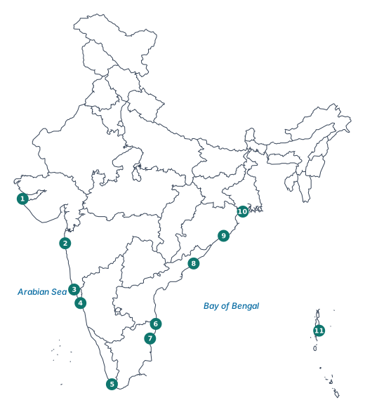
| No. | Beach | State / UT | Coast |
|---|---|---|---|
| 1 | Shivrajpur Beach, near Dwarka | Gujarat | West |
| 2 | Juhu Beach, Mumbai | Maharashtra | West |
| 3 | Calangute Beach | Goa | West |
| 4 | Om Beach, Gokarna | Karnataka | West |
| 5 | Kovalam Beach, Thiruvananthapuram | Keralam | West |
| 6 | Marina Beach, Chennai | Tamil Nadu | East |
| 7 | Promenade Beach | Puducherry (UT) | East |
| 8 | Ramakrishna (RK) Beach, Visakhapatnam | Andhra Pradesh | East |
| 9 | Puri Beach | Odisha | East |
| 10 | Digha Beach | West Bengal | East |
| 11 | Radhanagar Beach, Swaraj Dweep (Havelock Island) | Andaman and Nicobar Islands (UT) | Island |
Beaches on the west coast face the Arabian Sea, those on the east coast face the Bay of Bengal, and Radhanagar is on an island in the Andaman Sea.
In-text Questions — Pages 5–6Tides (Fig. 1.5)
Yes. The blue oval layer around the Earth is the ocean water. The pull of the Moon (and the Sun) stretches it into two bulges: one on the side facing the Moon and one on the opposite side.
- Places under a bulge have a higher water level: high tide.
- Places at the narrow sides of the oval, a quarter of the way round, have lower water: low tide.
As the Earth rotates, each place passes through both bulges and both narrow sides every day, so most places get two high tides and two low tides a day.
In (a) the Sun, Earth and Moon are in a line, the oval is most stretched, and the tides are highest and lowest (spring tide). In (b) the Sun and Moon pull at right angles, so the difference is smaller (neap tide).
THINK ABOUT IT — Page 8Ocean Currents (Fig. 1.9)
| Key | Currents |
|---|---|
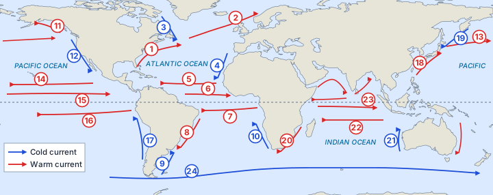
| Warm currents (red arrows) | 1 Gulf Stream; 2 North Atlantic Drift; 5 North Equatorial Current (Atlantic); 6 Equatorial Counter Current (Atlantic); 7 South Equatorial Current (Atlantic); 8 Brazilian Current; 11 Alaska Current; 13 North Pacific Drift; 14 North Equatorial Current (Pacific); 15 Equatorial Counter Current (Pacific); 16 South Equatorial Current (Pacific); 18 Kuroshio Current; 20 Agulhas Current; 22 South Equatorial Current (Indian); 23 Equatorial Counter Current (Indian) |
| Cold currents (blue arrows) | 3 Labrador Current; 4 Canaries Current; 9 Falkland Current; 10 Benguela Current; 12 California Current; 17 Humboldt (Peru) Current; 19 Oyashio Current; 21 West Australian Current; 24 West Wind Drift |
Movement patterns
- Warm currents (red) start near the Equator and flow towards the poles, mostly along the eastern coasts of continents: Gulf Stream, Kuroshio, Brazilian and Agulhas Currents.
- Cold currents (blue) flow from high latitudes towards the Equator, mostly along the western coasts: California, Humboldt (Peru), Canaries, Benguela and West Australian Currents.
- Together they form large loops, clockwise in the Northern Hemisphere and anticlockwise in the Southern Hemisphere, because of the winds and the Coriolis force.
- The cold West Wind Drift flows eastward all round Antarctica.
Yes, they affect coastal temperature. The warm Gulf Stream keeps the waters near Norway warm, so sea ice does not form easily there even at 60°–70° latitude. The cold Labrador Current brings sea ice and icebergs to lower latitudes off Canada (page 8).
LET’S EXPLORE — Page 8Ocean Currents around India (Fig. 1.9)
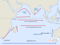
Notes from the map
- In the Arabian Sea, the current moves in a clockwise curve from the coast of Africa towards the west coast of India and on towards Sri Lanka.
- South of Sri Lanka, the current turns north-eastward into the Bay of Bengal.
- Just north of the Equator a current flows westward; just south of it the Equatorial Counter Current flows eastward, and further south the South Equatorial Current flows westward.
- All the arrows near India are red; no cold current reaches India’s coast.
Nature: the currents along India’s coast are warm currents, because they come from the warm tropical waters near the Equator. They are also seasonal: in the northern Indian Ocean the currents follow the monsoon winds and reverse direction between summer and winter.
LET’S EXPLORE — Pages 9–10Cyclones and Tsunamis — Early Warning Systems
Sample findings (examples of such traditions, and what a coastal family’s elders might say):
- On Simeulue, the story of smong (tsunami) says: if the ground shakes hard and the sea runs back, run to the hills. People did exactly this in 2004.
- After 2004, reports said that indigenous communities of the Andaman Islands, such as the Onge, also reached higher ground in time, guided by knowledge passed down by their elders.
- Fishing elders watch for signs of a coming storm: a heavy swell on a calm day, sea birds flying inland, and a sudden change in the wind and the colour of the sky.
How traditional knowledge helps:
- People act at once, without waiting for an official message.
- It works even when power, phones or the internet fail.
- Stories, songs and sayings are easy to remember and pass on to children.
It saves most lives when it works together with modern early warning systems.
THINK ABOUT IT — Page 14Making early warnings work
Five steps for the family:
- Stay calm and confirm. Check the alert on official sources (IMD, INCOIS, district administration, radio or TV). Do not spread rumours.
- Take the emergency kit: drinking water, dry food, medicines, torch, radio, charged phone and important documents in a waterproof bag.
- Move to safety as instructed. For a tsunami, go inland or to high ground at once, on foot if roads are crowded. For a cyclone, go to the nearest cyclone shelter or stay in a strong building away from windows.
- Help others and secure the home. Take care of elders, children and persons with disabilities; switch off electricity and gas; untie animals.
- Stay safe until the all-clear. Do not go to the beach to watch. A tsunami comes in several waves, and the calm eye of a cyclone is not its end.
LET’S EXPLORE — Page 18International Maritime Rules and Regulations
Some countries with disputes over sea areas:
| Sea area | Countries | What the disagreement is about |
|---|---|---|
| South China Sea | China, the Philippines, Vietnam, Malaysia, Brunei | Small islands and reefs, fishing, oil and gas, and busy sea routes |
| East China Sea | China and Japan | A group of small islands and the waters around them |
| Aegean Sea | Greece and Turkey | Width of territorial waters, islands and the continental shelf |
| Palk Strait | India and Sri Lanka | Fishermen crossing into each other’s waters |
| Sir Creek, Arabian Sea | India and Pakistan | A boundary in a tidal creek that also decides the sea boundary |
Some disputes have been settled peacefully under UNCLOS: the India–Bangladesh sea boundary in the Bay of Bengal was decided by an international tribunal in 2014.
Questions and activities — Page 20End of chapter
Fishing: the shallow, sunlit continental shelf (about 0–200 m deep) is rich in nutrients and marine life, so most fishing takes place there (pages 3 and 15). Seamounts and ridges attract fish in the open sea. Deep abyssal plains and trenches have few fish.
Transport: ships need enough depth. Shallow areas such as the Singapore Strait force very large tankers (VLCCs) to wait for high tide (page 7). Ports need deep water near the coast. Seamounts and reefs are hazards, so ships rely on charts made by bathymetry. Undersea cables must be laid along routes that avoid deep trenches and steep slopes.
Underwater exploration: the shelf is easiest to explore, so offshore oil and gas are drilled there. Abyssal plains hold deep-sea minerals, but reaching them needs special technology. Trenches such as the Mariana Trench are so deep, dark and high in pressure that very few people have ever reached their floor.
| Climate | Marine life | Human activities | |
|---|---|---|---|
| Waves | Mix the surface water with air, spreading heat | Shape coasts and build beaches where many creatures live | Beaches for tourism; storm waves and tsunamis destroy coastal property |
| Tides | Mix coastal waters twice a day | Fish move close to shore at high tide | Help ships enter harbours; better catch for fishermen; tidal energy (Gulf of Kutch, Gulf of Khambhat, Sundarbans) |
| Currents | Warm or cool coastal regions: the Gulf Stream keeps waters near Norway warm; the Labrador Current brings icebergs | Where warm and cold currents meet, waters are rich in nutrients | Rich fishing grounds; help or slow ships; affect rainfall and farming on coasts |
So these three movements spread heat, feed marine life and support trade, fishing and energy, but they can also bring disasters.
Marine resources are the materials and features of the oceans that have intrinsic or economic value. They are of two kinds: living (fish, marine organisms, aquatic plants) and non-living (minerals and energy). They are important for:
- Food and livelihood: fish are a major source of protein; fishing and aquaculture give work to millions.
- Energy: offshore oil and gas, and renewable “blue energy” from tides, waves and offshore wind.
- Minerals and materials: sand, gravel and deep-sea minerals.
- Trade and tourism: about 90% of world trade by volume is carried by sea; coastal tourism is a huge industry.
- Environment: coral reefs and other ecosystems support a great variety of plants and animals.
- Culture: the sacred śhaṅkha (conch) and kapardikā (cowrie shells, once used as money) are linked to the Samudra Manthana story.
For a country with a long coastline like India, they are the bedrock of local economies, so they must be used without harming marine ecosystems.
Sample poster
Message (2–3 sentences): Our seas give us food, jobs, energy and a steady climate, but plastic, oil spills and overfishing are killing marine life. If we keep plastic out of the sea, catch only as many fish as the sea can replace, and protect coral reefs and mangroves, the ocean will keep supporting us. Save Our Seas, for us and for the generations to come.
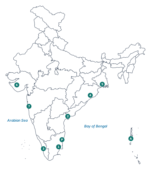
States marked: 1 Tamil Nadu, 2 Andhra Pradesh, 3 Keralam, 4 Odisha, 5 West Bengal. Also 6 Gujarat and 7 Maharashtra on the west coast, and the Union Territories A Andaman and Nicobar Islands and P Puducherry.
Reason: the east and south coasts face the earthquake zone near the Andaman Islands and Sumatra. In 2004, Tamil Nadu, Puducherry, Andhra Pradesh, Keralam and the Andaman and Nicobar Islands suffered the most damage (page 12).
Sample role-play plan
| Role | What they do after the warning |
|---|---|
| Scientists (IMD, INCOIS) | Track the cyclone by satellite and radar; forecast its path, landfall time, wind speed and storm surge; issue warnings |
| Officials (District Collector, disaster management) | Open cyclone shelters, order evacuation, close schools, stock food, water and medicines, keep rescue teams ready |
| Fisheries department, Coast Guard | Stop fishing; call boats back to shore; send alerts to fishermen through GEMINI |
| Panchayat members, volunteers | Go house to house, announce on loudspeakers, help elders and the disabled reach shelters |
| Coastal villagers | Pull boats ashore, tie down nets and roofs, pack emergency kits, move with their animals to shelters |
| Radio, TV, teachers | Spread correct information and stop rumours |
The play shows that a warning saves lives only when everyone plays their part quickly.
The principle of Innocent Passage.
It allows foreign ships to pass through a country’s territorial sea as long as they do not threaten its peace, good order or security. The conditions are:
- The ship must move continuously, without stopping, except in emergencies or breakdowns.
- It must not fish, carry out military operations or do anything else that is not peaceful.
- It must obey India’s laws in the zone, such as those on customs, immigration and pollution.
So the ship may pass, but it may not use India’s territorial sea for its own purposes.
In its EEZ, the country has special rights to explore, use and manage the natural resources of the water, the sea bed and the ground beneath it:
- Living resources: fish and other marine life; it decides who may fish and how much.
- Non-living resources: oil, natural gas and minerals.
- Energy from tides, waves, currents and winds, and the right to build rigs and other structures for these uses.
- The duty to conserve these resources and protect the marine environment.
However, the country does not fully own or control the waters of the EEZ: ships of other countries may still pass through peacefully (page 17).
Method: on a board or tray, paint the land and sea; mark the baseline and the 12, 24 and 200 nautical mile lines with string; add ship routes, protected zones and safety features with clay, paper and toothpick flags.
How the model follows maritime laws and protects the ocean:
- Maritime zones (UNCLOS) show where the country has control and where the high seas begin.
- Separate inbound and outbound shipping lanes with lighthouses and buoys follow COLREGs and prevent collisions.
- Marine protected area around the coral reef, closed to ships and fishing, conserves marine life (SDG 14).
- Fishing zone with seasonal limits regulates fishing and prevents overfishing.
- Oil rig with a safety zone in the EEZ uses the country’s resource rights safely.
- Tsunami buoy is part of the early warning system; a waste collection point at the port stops ships from dumping waste at sea (MARPOL).
Chapter 10 of 15 – Social Science
- Previous: Chapter 9 The Price Puzzle What Drives the Market
- Next: Chapter 11 Life on Earth
- All chapters: NCERT Solutions Class 9 Social Science
Also for This Chapter
NCERT Solutions Class 9 Social Science Chapter 10 Oceans and Life – Overview
| Class | Class 9 |
| Subject | Social Science |
| Chapter | 10 – Oceans and Life |
| Textbook pages | Part II, 1 – 20 |
| Questions solved | 24 |
| Session | 2027 |
| Format | Full answers on this page + PDF |
NCERT Solutions Class 9 Social Science Chapter 10 – FAQs
Where can I download NCERT Solutions Class 9 Social Science Chapter 10 Oceans and Life PDF?
Read every answer on this page, or download the free PDF from the table at the top.
Is this for the 2027 session?
Yes, it follows the latest NCERT Class 9 Social Science book for 2027.
How many questions are solved in NCERT Class 9 Social Science Chapter 10?
All 24 questions of the chapter (textbook pages Part II, 1 – 20) – the in-text questions, activities and the end-of-chapter exercises.
How should I use these solutions?
Read the chapter in the NCERT book first, attempt the questions yourself, then check your answers here.