NCERT Solutions for Class 9 Social Science Chapter 11 Life on Earth – step-by-step answers to every exercise and in-text question of the chapter, as per the latest NCERT syllabus for 2027. Read them online or download the free question-answer PDF.
This is Part II, Chapter 2 of Understanding Society: India and Beyond. It explains how climate and landforms divide the Earth into biomes — forests, grasslands, deserts, tundra and aquatic biomes — and how plants, animals and people adapt to each. It then shows how forests support livelihoods, how forest dwellers, sacred groves and laws such as the Forest Rights Act protect them, and how communities manage shared resources. You will be able to read a biome map, use the biome pyramid and explain why conserving biodiversity matters.
NCERT Solutions for Class 9 Social Science Chapter 11 Life on Earth PDF
All the answers are on this page below. The PDF also explains every answer – why it is right and how to check it – so download it for revision.
| Chapter | Download | |
|---|---|---|
| Solutions PDF | Life on Earth | View PDF |
NCERT Solutions for Class 9 Social Science Chapter 11 Life on Earth – Questions and Answers
All 37 questions of the chapter (textbook pages Part II, 21 – 43) are answered below, in the order of the book – in-text questions, activities and the end-of-chapter exercises. Each answer is written the way you would write it in the exam.
The Big Questions — Page 21Chapter opener
Climate (temperature and rainfall) and physiography (landforms and height above sea level) decide which plants can grow in a place; the plants decide which animals can live there; and together they decide how people live. This is why the Earth is divided into biomes.
- Hot and wet all year (near the Equator): dense tropical rainforests, as in the Amazon, the Congo and India’s Andaman & Nicobar Islands.
- Moderate rainfall: grasslands with grazing animals and farming.
- Very little rain: deserts with cacti, camels and lizards.
- Freezing cold: tundra with permafrost, mosses and lichens.
- Height: in the subtropical Himalaya, altitude brings conifer forests; Ladakh is a cold desert.
People adapt too: desert families store rainwater, hill farmers build terraces.
Humans and other life forms depend on each other through the biome they share.
- Nature supports people: forests give food, fuel, fodder, medicine, timber, bamboo and honey; rivers and lakes give water and fish; grasslands support livestock.
- Living beings support each other: animals pollinate flowers and spread seeds, and microorganisms recycle nutrients. Energy flows from plants to herbivores to carnivores (the biome pyramid).
- People change biomes: farming, cities, deforestation and forest fires damage them. Sacred groves, the Bishnoi and Chipko movements, and Mendha Lekha’s community forest show that people can also protect them.
So biomes and living beings form one system. When one part is harmed, the others suffer too.
Importance:
- Biodiversity keeps ecosystems healthy and maintains the balance of nature.
- Forests are a gene bank, keep oxygen levels up and balance the climate.
- Millions of people get food, medicine, fuel and income from forests, rivers and seas.
- Hotspots like the Western Ghats hold species found nowhere else; once lost, they are lost for ever.
How we can contribute:
- Support protected areas, wildlife corridors and community forest management (JFM, FRA).
- Behave responsibly as eco-tourists: no litter, no plastic, no noise, no feeding animals.
- Never start fires in forests; report fires quickly.
- Plant native trees, save water and respect sacred groves.
- Buy forest and GI products fairly, so that communities earn from protecting forests.
LET’S MAP — Page 22Biomes: world map of biomes (Fig. 2.2)
Look at the world map in Fig. 2.2 and answer the following questions.
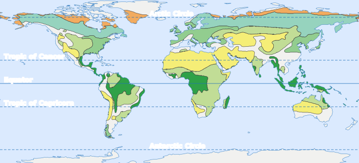
Which type of biome is found in smaller, separate regions, and why?
The tropical rainforest biome. It appears as separate patches: the Amazon Basin, Central America, the Congo Basin and coast of West Africa, eastern Madagascar, South-East Asia (Indonesia, Malaysia), New Guinea, a strip in north-east Australia, and small areas in India.
Why: a rainforest needs high temperature and heavy rainfall throughout the year. These conditions occur only near the Equator, between the Tropics. Even there, the land is broken up by oceans, and highlands such as the East African plateau and the Andes are cooler or drier. So the rainforest is found only in scattered lowland patches.
Leaving out Antarctica (covered by an ice sheet, so no biome is marked on it), Australia has the least number of biomes: only three — desert and grassland, with a small strip of tropical rainforest in the north-east. It has no temperate deciduous forest, taiga or tundra.
Reasons:
- Australia is the smallest continent and is compact in shape.
- Its mainland lies roughly between 10°S and 40°S, and the Tropic of Capricorn passes through its middle. Most of it is dry, so desert and grassland cover most of it.
- It does not reach the cold high latitudes, so there is no taiga or tundra.
- It has no very high mountain ranges to create cold mountain climates.
Some land areas are left white on the map because:
- They are covered by ice: Greenland and Antarctica have almost no plants or animals living on the land.
- They are high mountains and plateaus: the Himalaya and Tibet, the Rockies and the Andes. Here the climate changes quickly with height, so many kinds of vegetation are packed into a small area and cannot be shown as one biome.
- They belong to biomes not shown in the legend: the map shows only six biomes. Areas such as the lands around the Mediterranean Sea (chaparral or scrub) are not coloured.
- They are transition zones, where one biome slowly changes into another.
LET’S EXPLORE — Page 24Terrestrial Biomes: Forest Biome
Look at the layers of vegetation in a rainforest. What do the yellow shapes in the figure indicate?
The yellow shapes show how much sunlight reaches each layer of the rainforest.
- Emergent layer (full circle): the tallest trees rise above the rest and get full sunlight.
- Upper canopy (three-quarters): most of the light is still available, but the emergent trees take some.
- Understory/lower canopy (half): the thick canopy above blocks much of the light.
- Forest floor (quarter): very little sunlight reaches the ground, so it is dark and damp.
Each layer of leaves catches light, so less light reaches every layer below.
LET’S EXPLORE — Page 25Terrestrial Biomes: Grassland Biome
Observe Fig. 2.5 and explore which of these animals you will find in the grasslands of India.
Photograph: a grassland with dry golden grass, a few trees in the distance and a waterhole in front. The animals shown are an elephant, two lions, a giraffe, a zebra and a few antelopes (deer-like animals).
| Animal in Fig. 2.5 | Found in India’s grasslands? | Where |
|---|---|---|
| Elephant | Yes (the Asian elephant) | Grasslands of Kaziranga (Assam) and the Terai |
| Lion | Yes (the Asiatic lion) | Only in and around the Gir forest, Gujarat |
| Antelopes and deer | Yes | Blackbuck, chinkara and nilgai in the grasslands of Gujarat, Rajasthan and the Deccan; swamp deer (barasingha) in Kanha’s meadows |
| Giraffe | No | Found wild only in Africa |
| Zebra | No | Found wild only in Africa |
So the elephant, lion and antelopes can be seen in India’s grasslands; the giraffe and zebra cannot.
LET’S EXPLORE — Page 26Terrestrial Biomes: Desert Biome
People in deserts choose activities that need little water:
- Animal rearing: camels, goats and sheep give milk, wool, meat, hides and transport. Camels can go without water for many days.
- Dry farming in the rainy season: crops like bajra, jowar and pulses that need little water.
- Handicrafts: embroidery, mirror work, tie-and-dye, leather work and pottery.
- Tourism: camel safaris, desert festivals, forts and havelis.
- Salt-making in the Rann of Kutch during the dry season.
- Mining and work in oil fields, since many deserts have minerals and oil.
- Fetching and storing water, often done by women, as Fig. 2.6 shows.
Desert people have developed many ways to collect, store and save every drop of rain:
- Tanka or kund: an underground covered tank in a house or courtyard that collects rainwater from the roof or a sloping catchment.
- Nadi and johad: village ponds and small earthen dams that store rainwater for people and animals.
- Baoris (step wells) and small wells reach groundwater.
- Khadin: an earthen wall that holds rainwater on a field so the soil stays moist for crops.
- Canals: the Indira Gandhi Canal brings river water from Punjab to western Rajasthan.
- Saving water: drip irrigation, reusing water and growing crops that need little water.
Compare the physical features of the Rajasthan camel (Fig. 2.7a) and the Nubra Valley (Ladakh) camel (Fig. 2.7b).
Photographs of two camels. (a) Rajasthan camel: standing on dry sandy ground; it is tall, with long thin legs and one hump, and its coat is short and light brown. (b) Nubra Valley (Ladakh) camel: standing on stony ground; it has two humps, shorter legs and a stocky body, and is covered in long, thick, shaggy brown fur, especially on the neck, humps and upper legs.
| Feature | Rajasthan camel (Fig. 2.7a) | Nubra Valley camel (Fig. 2.7b) |
|---|---|---|
| Humps | One hump | Two humps |
| Height and legs | Tall, with long, thin legs | Shorter, with sturdier legs |
| Body | Slim | Stocky and heavy |
| Coat | Short, thin and light brown | Long, thick, shaggy and darker brown |
| Home | Hot, sandy desert (Thar) | Cold, high-altitude desert (Ladakh) |
Both have long necks and broad, padded feet for walking on sand and loose ground.
Because the two camels live in opposite kinds of desert.
- The Nubra Valley in Ladakh is a cold desert at a height of about 3,000 metres. Winters are long and temperatures fall well below 0 °C. The Nubra camel’s thick, dense fur traps air and keeps its body warm.
- Rajasthan is a hot desert, where summer temperatures often go above 45 °C. The Rajasthan camel’s short, thin coat lets body heat escape easily.
Thus fur density is an adaptation to climate.
THINK ABOUT IT — Page 27Terrestrial Biomes: Tundra Biome
Tundra in polar regions has mosses, lichens, shrubs, etc., while the Himalaya, in the subtropics, is dominated by conifers. What could be the reason for this? What difference do you find in the animals found in these two regions? Which species are found only in the Himalaya? Discuss in class.
Two photographs. Left: tundra — low grasses, mosses and shrubs among rocks, with snowy hills behind and no trees. Right: the Himalaya — a slope covered with dense, dark-green coniferous trees below snow-covered peaks.
(a) Reason: the tundra lies in high latitudes. Winters are long and dark, summers are short and cool, the ground stays frozen (permafrost) and cold winds blow, so trees cannot grow. The Himalaya lies in the subtropics (about 27°N–36°N). The Sun is higher and the growing season longer, and the soil is not permanently frozen. Between about 1,500 m and 3,000 m it is cool but not too cold, so conifers (pine, deodar, fir, spruce) grow. Only above about 3,600 m do trees give way to alpine shrubs and grasses.
(b) Animals: the tundra has reindeer, arctic foxes and polar bears. The Himalaya has snow leopards, yaks, musk deer and red pandas, as well as many birds.
(c) Found only in the Himalaya (and the high mountains next to it), never in the polar tundra: the Himalayan tahr, the Himalayan monal, the Himalayan snowcock, the red panda and the yak.
LET’S EXPLORE — Page 28Aquatic Biomes
Explore your local environment. This could be your village, city, town, or residential area. Observe how people, plants, and animals build structures and interact. Complete the table with your findings.
| Component type | Examples observed | Interaction with humans |
|---|---|---|
| Trees/Vegetation/Plants | ||
| Insects | ||
| Animals | ||
| Non-living things |
(a residential area of a small town):
| Component type | Examples observed | Interaction with humans |
|---|---|---|
| Trees/Vegetation/Plants | Neem, peepal, mango, banyan, tulsi, grass and shrubs in the park | Give shade, fruit, medicine (neem, tulsi) and fresh air; some are worshipped; people plant and water them but also cut them for roads and buildings |
| Insects | Honeybees, butterflies, ants, termites, mosquitoes | Bees pollinate fruit trees and give honey; termites damage wooden doors; mosquitoes spread diseases such as malaria and dengue |
| Animals | Cows, dogs, squirrels, sparrows, crows, pigeons, monkeys | Cows give milk; dogs guard houses; birds nest in buildings and trees; monkeys and pigeons take food; people feed and care for some animals |
| Non-living things | Soil, water (tank, taps, drain), air, sunlight, rocks, buildings, roads | People use water and soil for drinking and gardening; buildings and roads replace trees; drains carry waste water |
Structures: people build houses; birds build nests; ants make anthills; termites build mounds; spiders spin webs; bees make hives.
LET’S MAP — Page 29Biome Pyramid
Mark the following regions at appropriate levels on the Fig. 2.10: Andaman & Nicobar Islands, Keralam, Ladakh, Chhattisgarh, Odisha, Meghalaya, and Lakshadweep. Where will you place your home?
| No. | Biome | No. | Biome |
|---|---|---|---|
| 1 | Tundra | 6 | Desert |
| 2 | Coniferous Forest (Boreal Forest) | 7 | Rainforest |
| 3 | Deciduous Forest | 8 | Scrubland |
| 4 | Chaparral | 9 | Tropical Seasonal Forest |
| 5 | Grassland | 10 | Savanna |
| 11 | Desert | ||
| Region | Level and biome | Reason |
|---|---|---|
| Andaman & Nicobar Islands (A) | Tropical, wet end — 7 Rainforest | Hot and very wet all year; dense evergreen forests |
| Keralam (K) | Tropical, wet end — 7 Rainforest | Heavy monsoon rain; evergreen forests of the Western Ghats |
| Meghalaya (M) | Tropical, wet end — 7 Rainforest | One of the rainiest places in the world |
| Lakshadweep (L) | Tropical, wet side — between 7 and 8 | Hot and humid coral islands with coconut palms and scrub |
| Chhattisgarh (C) | Tropical, middle — 9 Tropical Seasonal Forest | Monsoon rain with a long dry season; sal forests |
| Odisha (O) | Tropical, middle — 9 Tropical Seasonal Forest | Deciduous forests of the plateau, as in Chhattisgarh |
| Ladakh (Lh) | Temperate, dry end — 6 Desert | Cold desert, like the Gobi: very cold and dry |
Sample home: Delhi (H) — bottom (tropical) row, dry side, between 10 Savanna and 11 Desert. It has very hot summers, low rainfall, thorny scrub and dry grasses.
The third (left) side runs from the tropical row at the base up to the polar region at the top, so an arrow drawn there would show latitude (and, on mountains, altitude). It would point upwards, in the same way as the other two arrows run from hot to cold and from wet to dry.
Moving up this arrow, places become colder and, as the chapter says, the number of organisms, biomass and available energy decrease (pages 28–29). The number of biomes also falls, from five in the tropical row to one (tundra) at the top. So the arrow would show that life becomes poorer as we go from the tropics towards the poles, or up a high mountain.
LET’S MAP — Page 31Maintaining Ecological Balance and Biodiversity
Mark and name the following regions on the map in Fig. 2.13. Also gather more information about these biodiversity regions from your teacher or other sources and discuss their features with your peers.
- Namdapha National Park
- Rann of Kutch
- Gahirmatha beach
- Gulf of Mannar
- Pachmarhi
- Achanakmar–Amarkantak
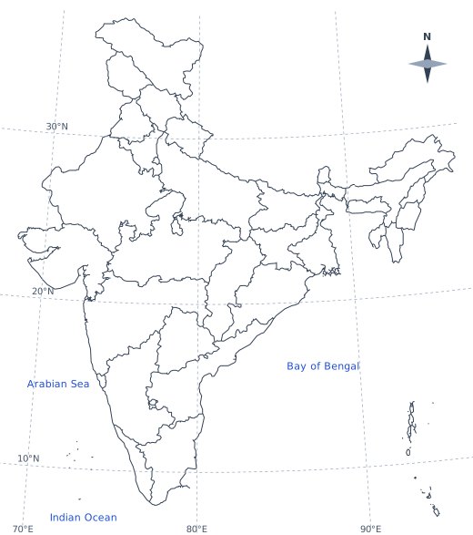
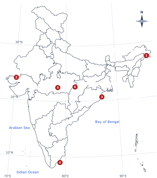
| No. | Region | State | Key feature |
|---|---|---|---|
| 1 | Namdapha National Park | Arunachal Pradesh | Eastern Himalayan forests, from tropical rainforest to snowy peaks |
| 2 | Rann of Kutch | Gujarat | Salt desert and seasonal wetland; Indian wild ass, flamingos |
| 3 | Gahirmatha beach | Odisha | Mass nesting site of olive ridley sea turtles |
| 4 | Gulf of Mannar | Tamil Nadu (sea between India and Sri Lanka) | Coral reefs, sea grass and the dugong (sea cow) |
| 5 | Pachmarhi | Madhya Pradesh | Satpura hills; biosphere reserve with sal and teak forests |
| 6 | Achanakmar–Amarkantak | Chhattisgarh and Madhya Pradesh | Biosphere reserve in the Maikal hills; source of the Narmada and Son rivers |
LET’S EXPLORE — Pages 32–33Forest Ecotourism: Thenmala Ecotourism in Keralam
Thenmala, located in the Kollam district of Keralam, is India’s first planned ecotourism destination, developed jointly by the Tourism Department, the Forest Department, and the Irrigation Department of Keralam. The name Thenmala means ‘Honey Hill’ … The project was launched to promote sustainable tourism while conserving forests and supporting local communities, by employing the inhabitants as guides, eco-guards, and service providers … (Fig. 2.14).
Is there any such ecotourism site in your State/UT? Collect some information and discuss with your friends.
Sample answer — Meghalaya: the living root bridges near Sohra.
- What: bridges grown over many years by Khasi villagers, who guide the roots of rubber fig trees across streams. Villages such as Nongriat (with a famous double-decker bridge) and Mawlynnong, known for its cleanliness, receive many visitors.
- Ecotourism features: visitors trek through forest; villagers work as guides and run homestays and small shops; entry fees help the village; plastic and littering are discouraged.
- Benefit: tourism gives income to local people while the forest and traditional knowledge are protected, just like Thenmala.
What should be a tourist’s behaviour while visiting any tourist site? What should one be mindful of?
Photograph: visitors walking on a raised wooden and steel walkway through the tree canopy of a dense forest.
A responsible tourist should:
- Leave no waste: carry back plastic, bottles and wrappers.
- Stay on marked paths and follow the rules of the site and the guides.
- Not disturb wildlife: no feeding, chasing, shouting or loud music; keep a safe distance.
- Not pluck plants, carve on trees or rocks, or take away anything natural.
- Never light fires or throw away matches in a forest.
- Save water and electricity.
- Respect local people: their customs, sacred places and privacy; ask before taking photos.
- Support the local economy: hire local guides and buy local products.
Map activity (Fig. 2.16) — Page 34Forests and Livelihoods: forest produce of Indian states
Fig. 2.16 is a map of India showing forest produce from different Indian states (map not to scale). It lists:
| Forest produce | States shown |
|---|---|
| Timber and bamboo | Assam, Tripura, Keralam |
| Tendu leaves, mahua flowers, sal seeds, gums | Madhya Pradesh, Chhattisgarh |
| Herbs like ashwagandha, neem, and tulsi | Himalayan region, Western Ghats |
| Wild fruits, honey, mushrooms, and roots | Jharkhand, Odisha |
| Ecotourism | Uttarakhand, Assam, Keralam |
| Handicrafts and cottage industries | Rajasthan, Keralam |
You may add some examples of forest produces from your own state/UT in the map above.
Sample answer — Maharashtra:
| Forest produce | Where in the state |
|---|---|
| Bamboo | Gadchiroli and Chandrapur (Vidarbha); Mendha Lekha village harvests bamboo |
| Tendu leaves (for bidi) and mahua flowers | Forests of Gadchiroli, Gondia and Chandrapur |
| Kokum, karvanda and jamun (wild fruits) | Konkan and the Western Ghats |
| Hirda (a medicinal fruit) and other herbs | Forests of the Sahyadri (Western Ghats) |
| Honey | Forests of the Western Ghats, such as around Mahabaleshwar |
On the map, draw a small symbol for each product at the right place in your state and add it to the key.
LET’S EXPLORE — Page 36Forest Dwellers
Try to identify and classify the items for sale in the images given in Fig. 2.18.
Four photographs of a market. Top left: a woman carrying a very large, round woven basket on her head; many more big baskets stand stacked behind her. Top right: two women sitting beside woven baskets filled with small, round, yellow-orange fruits. Bottom left: women sitting on the ground selling small heaps of brown roots or tubers spread on sheets. Bottom right: two hands, one holding knobbly ginger-like roots (rhizomes) and the other holding small dried fish.
| Item in the picture | What it is | Class |
|---|---|---|
| Large woven baskets | Made from bamboo or cane | Handicraft (forest-based cottage industry) |
| Small yellow-orange fruits in baskets | Wild forest fruits | Food — non-timber forest produce |
| Roots and tubers on the ground | Wild roots and tubers | Food — non-timber forest produce |
| Ginger-like roots (rhizomes) | Ginger or turmeric-type roots | Spice / medicinal produce |
| Small dried fish | Fish from streams, rivers or lakes | Food — from fresh water |
So the items fall into three groups: food, medicinal or spice plants, and handicrafts. All of them come from forests or nearby waters, and are collected or made by tribal families to earn an income.
Sample list (a weekly market in central India):
| Food varieties | Medicinal varieties |
|---|---|
| Mahua flowers (dried) | Amla (Indian gooseberry) |
| Jamun, ber and wild mango | Harad and baheda (dried fruits used in triphala) |
| Chironji seeds | Giloy stems |
| Honey | Ashwagandha roots |
| Tamarind | Neem leaves and twigs |
| Mushrooms (in the rainy season) | Tulsi leaves |
| Bamboo shoots, wild leafy greens | Turmeric and ginger |
Many of these come from nearby forests and are sold by local or tribal sellers.
LET’S EXPLORE — Page 38Geographical Indication (GI): GI-tagged forest products in India
The GI-tagged forest products shown in Fig. 2.19 (page 37) are:
| No. | GI-tagged forest product | State | Link with the forest (from the book) |
|---|---|---|---|
| 1 | Ramban Sulai Honey | Jammu and Kashmir | Nutritious; strong antioxidant and immuno-modulatory potential; distinct flavour, aroma and taste |
| 2 | Tezpur Litchi | Assam | Grown in forest-influenced soil and climate; bright colour, high pulp |
| 3 | Channapatna Toys | Karnataka | Made from Wrightia tinctoria, a forest tree (‘Aale mara’) |
| 4 | Kandhamal Haldi | Odisha | Turmeric grown by tribal communities in forest regions; high curcumin |
| 5 | Erode Manjal (Erode Turmeric) | Tamil Nadu | Grown in forest-influenced soils; cooking and ayurvedic medicine |
| 6 | Nilgiri Tea | Tamil Nadu, Keralam, Karnataka | Plantation-based, but quality depends on Western Ghats forest conditions |
| 7 | Tripura Queen Pineapple | Tripura | Forest-dependent cultivation; sweetness and aroma |
| 8 | Khasi Mandarin | Meghalaya | Citrus fruit from the forest-rich hills |
Can you explain how GI tagging of the forest products mentioned above connects geography, cultural traditions, local governance, and rural economy?
- Geography: a GI tag exists because the product’s quality comes from its place, from its soil, climate and forest. Kandhamal Haldi gets its high curcumin from forest regions of Odisha; Nilgiri Tea depends on Western Ghats conditions.
- Cultural traditions: many GI products rest on traditional knowledge passed down generations. Channapatna toys are made from a forest tree; Kandhamal Haldi is grown by tribal communities.
- Local governance: producers’ groups, cooperatives and community bodies register the tag, keep up quality standards and stop others from misusing the name. Communities such as Gram Sabhas also manage the forests these products depend on.
- Rural economy: the tag gives exclusive market recognition, so genuine products earn better prices. This raises rural incomes and creates jobs.
So GI tagging links a place, its people, their institutions and their income.
Sample answer — forest-linked GI products from some states:
| State | GI-tagged product | Forest link |
|---|---|---|
| Odisha | Kandhamal Haldi; Similipal Kai Chutney | Turmeric from forest regions; chutney made from red weaver ants collected in the Similipal forests |
| Karnataka | Channapatna Toys; Mysore Sandal Soap; Coorg Orange | Wood of a forest tree; sandalwood oil; oranges from the forested hills of Kodagu |
| Andhra Pradesh | Araku Valley Arabica Coffee | Grown by tribal farmers in the forested Eastern Ghats |
| Nagaland | Naga Mircha (Naga king chilli) | Grown in the hills of Nagaland |
| Assam | Tezpur Litchi; Karbi Anglong Ginger | Forest-influenced soils of Assam’s hills |
| Chhattisgarh | Bastar Dhokra | Metal craft of tribal artisans of the forested Bastar region |
Name the products listed for your own state/UT.
LET’S EXPLORE — Page 39Challenges Faced by People Living in Forests: Pradhan Mantri Ujjwala Yojana
The Pradhan Mantri Ujjwala Yojana (launched in 2016) gives LPG cooking-gas connections, in the name of women, to poor households. Its effects on women’s health:
- Cleaner air at home: cooking on firewood, cow-dung cakes or coal fills the kitchen with smoke. LPG burns cleanly, so women breathe less smoke.
- Fewer illnesses: less coughing, breathing problems, lung disease and eye irritation.
- Less hard work: women and girls spend less time and effort collecting and carrying heavy loads of firewood.
- Safety: fewer burns from open fires, and less danger while going into forests for fuelwood.
- Time saved for rest, children, education or earning.
THINK ABOUT IT — Page 39Challenges Faced by People Living in Forests: human–wildlife conflict
Which wild animals (like monkeys or deer) have you seen in your residential area?
Photograph (aerial view): a wide road cutting through a dense conifer forest, with a broad bridge covered in soil and plants built across the road, joining the forest on both sides.
In my residential area I have seen:
- Monkeys (rhesus macaques and langurs) on rooftops and trees;
- Peafowl in gardens and fields;
- Nilgai (blue bull) and wild boar in farms at the edge of the town;
- Jackals at night near open land;
- Snakes such as rat snakes and cobras in the rainy season.
Spotted deer are often seen in towns near forests; elephants and leopards sometimes enter villages near reserves.
- Loss of habitat: forests are cut for farms, roads, houses and mines, so animals lose their homes.
- Broken corridors: roads and railways cut through forests and block animal routes, pushing animals into villages.
- Easy food: crops, fruit trees, garbage and food thrown by people attract monkeys, boars, deer and elephants.
- Feeding by people: animals that are fed lose their fear and keep coming back.
- Shortage of water and food in the forest, especially in summer or drought.
- Towns spreading into forest edges, so people and animals now share the same land.
LET’S EXPLORE — Page 42Ecological Commons: Case Study of Water Tanks Built by the Gond Kings
Below is Fig. 2.24 from the School Bhuvan–NCERT Geoportal. Observe the image carefully and see if you can identify some of the tanks and mark the agricultural fields irrigated by them.
Satellite image (seen from above): a grey-brown patchwork of small fields with many small dark-green or almost black patches scattered across it. Near the centre is a large, roughly round area with a curved, light-brown band along its left side. One road runs diagonally from the left edge towards the bottom; another curves down the right side; a built-up village area appears at the top right.
How to identify the tanks:
- Water absorbs most light, so tanks look dark — black, dark blue or dark green — with a smooth texture and clear edges. The many small dark patches scattered over the image are small tanks.
- A tank has an earthen embankment (bund) on its lower side to hold the water. The large round area in the centre, edged by a curved light-brown band, looks like a big tank whose bed is partly dry, with its bund or silt showing as the light band.
Fields irrigated by them: the greener fields lying just next to and below each tank, on the downhill side of the bund, receive its water through small channels. Mark them by shading the green fields around each dark patch and drawing an arrow from the tank to them. Fields that look bare and grey-brown, far from any tank, are not irrigated.
Questions and Activities — Page 43End-of-chapter exercises
India has diverse biomes because it has a great variety of climates and landforms within one country.
- Latitude: India stretches from about 8°N to 37°N, and the Tropic of Cancer passes through its middle, so it has both tropical and subtropical climates.
- Altitude: land rises from sea level to the snowy Himalaya, so the temperature changes with height.
- Rainfall: it ranges from over 400 cm in parts of Meghalaya to less than 10 cm in Ladakh and western Rajasthan.
- Coasts and islands: long coastlines, deltas, coral islands and two island groups.
Local geography creates local biomes: rainforests in the Andaman & Nicobar Islands, the Western Ghats and the North-East; deciduous forests in central India; the hot Thar Desert and the salt desert of the Rann of Kutch; the cold desert of Ladakh; conifers and alpine meadows in the Himalaya; mangroves on the coasts.
(central India — Madhya Pradesh and Chhattisgarh):
| Native plant | Economic value | Abundance (sample observation) |
|---|---|---|
| Sal | Timber; sal seeds for oil; leaves for plates | Common in forests, but large old trees are fewer |
| Teak | Valuable timber for furniture and buildings | Common, much of it in plantations |
| Tendu | Leaves used to make bidis; seasonal income for forest dwellers | Abundant |
| Mahua | Flowers for food and oil; seeds for oil | Common near villages, but few young trees seen |
| Bamboo | Baskets, mats, building, paper | Common, but reduced where over-cut |
| Amla, harad, baheda | Medicinal fruits | Moderately common |
| Chironji | Costly dry fruit (seeds) | Declining, as fruits are often picked before seeds can grow |
Comment: many of these plants are still common, but several are declining because of over-harvesting, forest fires, grazing and clearing of forests. They need sustainable collection and replanting.
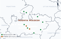
Sample map: Madhya Pradesh. National parks shown: Kanha, Bandhavgarh, Pench, Satpura, Panna, Madhav, Kuno and Van Vihar (Bhopal). Wildlife sanctuaries shown: Pachmarhi and Ratapani.
Steps to make your own map: (1) take an outline map of your state; (2) list its national parks and sanctuaries from the State Forest Department website or an atlas; (3) mark each with a symbol (for example, a green dot for a national park and a brown square for a sanctuary); (4) write the names; (5) add a title, a key and a north arrow.
Causes:
- Human-induced (most common): burning land for farming; burning the forest floor to collect mahua flowers or to grow fresh grass for cattle; careless campfires, cigarettes and matches.
- Natural: lightning, high temperatures and dry leaf litter, made worse by climate change.
Losses to forest-dependent people:
- Homes, crops, stored grain and cattle may burn.
- Loss of income from honey, tendu leaves, fruits, bamboo and medicinal plants.
- Shortage of firewood, fodder and water; smoke causes breathing and eye problems.
- Wildlife and soil are damaged, so the forest gives less for years afterwards.
Preventive measures: clearing fire lines (gaps in the forest), removing dry leaf litter, watch towers and satellite fire alerts, awareness drives, community fire watchers, safe methods of collecting forest produce, and quick reporting of fires.
Forests are called the ‘lungs of the Earth’ because, like lungs, they exchange gases with the air and keep it fit for life.
- Through photosynthesis, trees take in carbon dioxide and release oxygen, helping to maintain oxygen levels.
- They store huge amounts of carbon in wood, leaves and soil, so they act as a carbon sink and help balance the Earth’s climate.
- Leaves trap dust and smoke, so they clean the air.
- Through transpiration they release water vapour, which cools the air and helps form rain.
Large-scale destruction of forests would make the global climate warmer and less stable:
- More carbon dioxide: cut or burnt trees release stored carbon, and fewer trees remain to absorb it. More CO₂ traps more heat, causing global warming.
- Less rainfall and more droughts: forests return water vapour to the air; without them rainfall falls in many regions and droughts become more common.
- Hotter local climates: the cooling effect of shade and transpiration is lost.
- More extreme events: heatwaves, floods, storms and forest fires increase.
- Rising sea levels: warming melts glaciers and ice sheets.
- Loss of biodiversity, which weakens nature’s ability to recover.
Sample notes from a discussion with an elderly person:
- Sacred groves: patches of forest belonging to the village deity, where no tree may be cut and no animal hunted.
- Worship of trees and animals: peepal, banyan, neem and tulsi are worshipped; some trees are never cut. The Bishnoi community protects khejri trees and blackbuck.
- Taking only what is needed: collecting fallen or dead wood instead of cutting live trees; lopping branches instead of felling whole trees; leaving some fruit and honey for animals and new growth.
- Seasonal rules: no collection during flowering or breeding seasons; rituals before collecting forest produce, as the Gonds and Bhils do.
- Community guarding: villagers take turns to patrol the forest. In Odisha this is called thengapalli (passing a stick from house to house); in Uttarakhand, Van Panchayats manage village forests.
- Rotational grazing, so that grass can grow back.
- Knowledge holders: they know which herbs, plants and forest resources are useful and how to use them sustainably. This knowledge, passed down generations, helps biodiversity conservation.
- Forest protection movements: they have led movements such as the Bishnoi Movement in Rajasthan, led by Amrita Devi, and the Chipko Movement in Uttarakhand, where village women hugged trees to prevent deforestation.
- Community forest management: in Mendha Lekha (Gadchiroli, Maharashtra), the Gond villagers protect 1,800 hectares of forest through their Gram Sabha by regulating tree cutting, preventing forest fires and harvesting bamboo sustainably.
- Cultural guardianship: rituals, festivals, sacred groves and beliefs make them guardians of ecological and cultural traditions.
- Joint Forest Management: they help forest departments protect forests in return for a share of forest produce.
- Eco-restoration: they replant and restore damaged forests.
A forest fire is an uncontrolled fire that spreads through a forest, burning trees, shrubs, grass and dry leaf litter. It may be started by people or by natural causes such as lightning, and spreads fast in hot, dry and windy weather.
Plan for prevention and mitigation:
| Stage | Actions |
|---|---|
| Before (prevention) | Clear fire lines and remove dry leaf litter before summer; ban fires and burning in the dry season; teach villagers and tourists not to drop matches or cigarettes; train village fire-watch volunteers; set up watch towers and use satellite fire alerts |
| During (response) | Report the fire at once to the forest office or emergency number 112 (fire: 101); move people and cattle to safety; beat out small fires with green branches; dig trenches to stop the spread; firefighters control larger fires |
| After (recovery) | Help affected families; treat injuries; replant native trees; protect burnt areas from grazing so they can recover; study the cause to prevent it next time |
Chapter 11 of 15 – Social Science
- Previous: Chapter 10 Oceans and Life
- Next: Chapter 12 Resistance and Resilience (1000–1700 CE)
- All chapters: NCERT Solutions Class 9 Social Science
Also for This Chapter
NCERT Solutions Class 9 Social Science Chapter 11 Life on Earth – Overview
| Class | Class 9 |
| Subject | Social Science |
| Chapter | 11 – Life on Earth |
| Textbook pages | Part II, 21 – 43 |
| Questions solved | 37 |
| Session | 2027 |
| Format | Full answers on this page + PDF |
NCERT Solutions Class 9 Social Science Chapter 11 – FAQs
Where can I download NCERT Solutions Class 9 Social Science Chapter 11 Life on Earth PDF?
Read every answer on this page, or download the free PDF from the table at the top.
Is this for the 2027 session?
Yes, it follows the latest NCERT Class 9 Social Science book for 2027.
How many questions are solved in NCERT Class 9 Social Science Chapter 11?
All 37 questions of the chapter (textbook pages Part II, 21 – 43) – the in-text questions, activities and the end-of-chapter exercises.
How should I use these solutions?
Read the chapter in the NCERT book first, attempt the questions yourself, then check your answers here.