NCERT Solutions for Class 7 Social Science Chapter 14 India and Her Neighbours – step-by-step answers to every exercise and in-text question of the chapter, as per the latest NCERT syllabus for 2027. Read them online or download the free question-answer PDF.
Answers to Chapter 14, India and Her Neighbours — the second chapter of Theme A, India and the World: Land and the People, in Exploring Society: India and Beyond (Grade 7, Part 2). Every question the chapter asks is answered here: the three Big Questions, all three LET’S EXPLORE boxes, the DON’T MISS OUT question on the Kartarpur Corridor, the question in the caption of Fig. 2.10, the four points of Before we move on …, and all eight end-of-chapter Questions and activities. The boxes that carry no question — the remaining DON’T MISS OUT boxes on maritime neighbours, the Indian Ocean, Quanzhou, open borders, Bhutan’s rivers, the three schools of Buddhism, Gross National Happiness, the Ananda temple, SAARC, Dhivehi, the Chakri kings, the stūpa and the 2004 tsunami — are folded into the answers and the revision table below. Every statement about borders and relations here is exactly what the textbook states, and nothing more.
NCERT Solutions for Class 7 Social Science Chapter 14 India and Her Neighbours PDF
All the answers are on this page below. The PDF also explains every answer – why it is right and how to check it – so download it for revision.
| Chapter | Download | |
|---|---|---|
| Solutions PDF | India and Her Neighbours | View PDF |
NCERT Solutions for Class 7 Social Science Chapter 14 India and Her Neighbours – Questions and Answers
All 20 questions of the chapter (textbook pages Part II, 29 – 60) are answered below, in the order of the book – in-text questions, activities and the end-of-chapter exercises. Each answer is written the way you would write it in the exam.
The Big Questions — Page 29Chapter opening — Theme A, India and the World: Land and the People
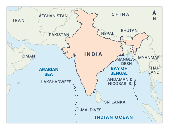
No. A shared land border is only one way of being a neighbour. Pakistan, Afghanistan, China (Tibet), Nepal, Bhutan, Bangladesh and Myanmar share land borders with India — neighbours in the traditional sense. But India is a maritime nation with sea on three sides, so countries joined to her by the sea are neighbours too: Sri Lanka and the Maldives close by, and Iran, Oman, Thailand, Malaysia, Singapore and Indonesia further out. Shared history, trade and culture also make neighbours.
Geography decides how easily India can reach a neighbour; history decides how the two feel about each other.
- Geography: the Himalayas separate India and China, yet Buddhism crossed them; shared rivers link India with Bangladesh and Bhutan; the sea links India with Sri Lanka, the Maldives and Southeast Asia.
- History: Buddhism and old trade routes built lasting ties with many neighbours; the 1947 Partition left a complex relationship with Pakistan; Bangladesh, born in 1971, became a close partner.
India and her neighbours are connected today through:
- trade — with China, Nepal, Malaysia and Singapore;
- treaties and easy movement — the open border with Nepal (1950 treaty), the Kartarpur Corridor, the 2018 border agreement with Myanmar, SAARC;
- connectivity projects — the India–Myanmar–Thailand Trilateral Highway, Chabahar Port, hydroelectric projects in Bhutan;
- religion and culture — Buddhism, festivals, languages, films;
- disaster relief and security — tsunami early warning, help to the Maldives, joint exercises with Oman.
LET’S EXPLORE — Page 30Framing the Neighbourhood — reading the map of routes (Fig. 2.2)

A — the Arabian Sea (to the west of India)
B — the Bay of Bengal (to the east)
C — the Indian Ocean (to the south)
DON’T MISS OUT — Page 36India and Pakistan — the Kartarpur Corridor
Yes, it can. India and Pakistan share “one of the most complex relationships in South Asia”, yet they agreed on the Kartarpur Corridor — a visa-free crossing (only a permit is needed) that lets Indian pilgrims visit Gurdwara Darbar Sahib, the final resting place of Guru Nānak Dev. It shows that small, practical steps built on shared faith can bring people together. But it took nearly thirty years to open and has not ended the wider tension.
In-text Question — Page 40The ‘Land of the Thunder Dragon’ — the emblem of Bhutan (Fig. 2.10)
Apart from the dragons, the emblem has a crossed vajra (thunderbolt) at the centre, a lotus below it and a jewel at the top — symbols familiar from India’s Buddhist and Hindu art. The vajra gives Vajrayāna Buddhism its name; Guru Padmasambhava brought Vajrayāna from India to Bhutan in the 8th century CE. The lotus is one of the oldest Indian symbols of purity.
LET’S EXPLORE — Page 51From Dvārakā to Dvāravatī and Ayodhyā to Ayutthayā — the sculpture at Bangkok airport (Fig. 2.21)
Yes. ‘Suvarnabhumi’ is the Sanskrit Suvarṇabhūmi, the ‘golden land’. The chapter says ancient Indian traders sailing to Java, Sumatra and Malaya in search of gold called these lands Suvarṇabhūmi (golden land) or Suvarṇadvīpa (golden island). So Thailand’s main airport carries a name linked with Indian traders of over two thousand years ago, and its samudra manthana sculpture shows a Hindu myth — both signs of India’s old cultural link with Thailand.
LET’S EXPLORE — Page 53The ‘Lion City’ — Tamil as an official language of Singapore (Fig. 2.23)
It suggests that south India and Singapore have a long and close relationship. Many people of south Indian (Tamil) origin must have settled in Singapore over the centuries — so many that Tamil is an official language, used even on public signs (Fig. 2.23). The chapter adds that Indian traders and monks visited the region a few centuries BCE, and about 9 per cent of Singapore’s residents today are of Indian origin.
Before we move on … — Page 59The chapter in four points
This point means that India’s ideas, beliefs and arts spread to her neighbours through centuries of contact, and can still be seen there. For example: Buddhism in Sri Lanka, Myanmar, Thailand and Bhutan; Thai kingdoms named Dvāravatī and Ayutthayā after Dvārakā and Ayodhyā; a Brāhmī-based script in Malaysia; Garuḍa on Indonesia’s currency and the Borobudur Stūpa; Tamil as an official language in Singapore.
Along with goods, these old routes carried religion, language, art and ideas.
- Uttarāpatha — from the Ganga plains to Central Asia via Afghanistan; it carried Buddhism, Hinduism, art and philosophy.
- Dakṣhiṇāpatha — the southern route, towards the peninsula.
- Silk Route — land routes through present-day Pakistan and Afghanistan, linking India with Iran and beyond.
- Spice (sea) routes — across the Arabian Sea and the Bay of Bengal to the Arabian Peninsula and Southeast Asia.
India’s traditions spread through traders, monks, pilgrims and scholars — not through armies. Buddhism reached China “via trade and pilgrimage routes”; Mahendra and Sanghamitrā took it to Sri Lanka, and Guru Padmasambhava took Vajrayāna to Bhutan. Traders carried Indian names, stories and scripts to Southeast Asia. Neighbours adopted them freely: Thai kingdoms took the names Dvāravatī and Ayutthayā, and Malaysia adopted a Brāhmī-based script.
India is reviving the old links in three ways:
- Connectivity projects — the India–Myanmar–Thailand Trilateral Highway, Chabahar Port in Iran, the Zaranj–Delaram highway in Afghanistan, the Kartarpur Corridor.
- Films, music and television — e.g. the Hindi word filmu is used in the Maldives, thanks to Bollywood.
- Shared strategic and trade interests — maritime security with Indonesia and Malaysia, joint military exercises with Oman, trade with Malaysia and Singapore.
Questions and activities — Page 60End-of-chapter exercise
A maritime neighbour is a country connected to another by a shared sea or ocean, even without a direct land border. The ocean links such countries through trade, cultural exchange and historical ties.
Two examples for India:
- Sri Lanka — to the southeast, across the Palk Strait; only about 32 km away at the nearest point.
- The Maldives — a nation of over 1,100 islets, about 130 km from Minicoy (Lakshadweep).
Buddhism began in India and spread to her neighbours through monks, pilgrims and traders.
- Sri Lanka: brought in the 3rd century BCE by Mahendra and Sanghamitrā, Aśhoka’s son and daughter.
- China: reached around the 1st century CE; Faxian and Xuanzang came to India; Kumārajīva went to China.
- Bhutan: Guru Padmasambhava brought Vajrayāna in the 8th century CE; Bhutanese pilgrims still visit Bodh Gaya.
- Myanmar: its people come to India on pilgrimage; India helped restore the Ananda temple at Bagan.
An ‘open border’ means people of two countries can cross the border without a passport or visa. India and Nepal have such a border under the 1950 Treaty of Peace and Friendship. For people living along it: families on both sides stay connected; people cross easily for work, education and healthcare; border markets and trade thrive; pilgrims visit sacred sites such as the Paśhupatinātha temple. Both countries work together so that the open border is not misused.
It means that countries are neighbours not only because they lie close on the map, but also because of shared history, culture and cooperation. Example: Indonesia shares no land border with India, yet the two are close maritime neighbours — linked by trade for over 2,000 years, by the Rāmāyaṇa and Garuḍa (on Indonesia’s currency), and today by joint work on maritime security and disaster relief.
India has helped her smaller neighbours in several ways:
- Disaster relief — quick help to the Maldives in the 2004 tsunami, the 2014 Malé water crisis and COVID-19.
- Infrastructure — the Afghan Parliament building and the Zaranj–Delaram highway in Afghanistan.
- Energy — hydroelectric projects in Bhutan, such as Tala, built with India’s support.
- Heritage — restoring the Ananda temple at Bagan, Myanmar.
- Early warning — the tsunami warning centre in Hyderabad alerts neighbouring countries too.
When a problem crosses borders, no country can solve it alone, so neighbours work together — the problem becomes a chance to cooperate. Yes, the chapter gives examples: after the 2004 tsunami, India joined Indonesia, Sri Lanka, Thailand and others to build an early warning network; India and Bangladesh jointly protect the Sundarban; the Maldives, threatened by rising seas, works with India in the International Solar Alliance; India works with Indonesia, Malaysia and Oman on maritime security.
The map would have few sharp lines. It would show overlapping zones — a Bangla zone covering West Bengal and Bangladesh; a Himalayan zone joining Nepal, Bhutan and India’s Himalayan states; a Tamil zone linking Tamil Nadu with Sri Lanka, Malaysia and Singapore; a Buddhist zone from Sri Lanka through Myanmar and Thailand to Bhutan and China; and an undivided Punjab. But such zones overlap and change over time, so this map would be hard to draw.
- Label India’s neighbours.
- Draw arrows showing cultural flows (e.g., food, festivals, languages) between India and her neighbours.
- Imagine and redraw new “borders of friendship” that connect neighbours through rivers, trade routes, or cultural zones.
- Collect pictures of the flags of the countries listed in this chapter and write your observations.
Sample answer (four parts):
- Labels: land neighbours — Pakistan, Afghanistan, China, Nepal, Bhutan, Bangladesh, Myanmar; maritime neighbours — Sri Lanka, the Maldives, Iran, Oman, Thailand, Malaysia, Singapore, Indonesia.
- Arrows: India → Sri Lanka: Buddhism; India ↔ Nepal: Daśhain, Tihar, Holi; India → Maldives: Tamil words, coconut curries.
- Borders of friendship: a Ganga–Brahmaputra river zone (India–Bangladesh), a Himalayan pilgrim zone (India–Nepal–Bhutan), a Bay of Bengal trade zone.
- Flags: India’s Aśhoka Chakra and Bhutan’s dragon show Buddhist links; Nepal’s flag is not rectangular.
Chapter 14 of 20 – Social Science
- Previous: Chapter 13 The Story of Indian Farming
- Next: Chapter 15 Empires and Kingdoms: 6th to 10th Centuries
- All chapters: NCERT Solutions Class 7 Social Science
Also for This Chapter
NCERT Solutions Class 7 Social Science Chapter 14 India and Her Neighbours – Overview
| Class | Class 7 |
| Subject | Social Science |
| Chapter | 14 – India and Her Neighbours |
| Textbook pages | Part II, 29 – 60 |
| Questions solved | 20 |
| Session | 2027 |
| Format | Full answers on this page + PDF |
NCERT Solutions Class 7 Social Science Chapter 14 – FAQs
Where can I download NCERT Solutions Class 7 Social Science Chapter 14 India and Her Neighbours PDF?
Read every answer on this page, or download the free PDF from the table at the top.
Is this for the 2027 session?
Yes, it follows the latest NCERT Class 7 Social Science book for 2027.
How many questions are solved in NCERT Class 7 Social Science Chapter 14?
All 20 questions of the chapter (textbook pages Part II, 29 – 60) – the in-text questions, activities and the end-of-chapter exercises.
How should I use these solutions?
Read the chapter in the NCERT book first, attempt the questions yourself, then check your answers here.